LiDAR is one of the most valuable technologies available for forestry and vegetation analysis, but there is still a lot of misunderstanding around what it can and cannot do in dense grass, shrubs, brush, and canopy. In Alberta and British Columbia, where terrain and vegetation conditions vary dramatically, the difference between average LiDAR and well-executed LiDAR can be huge.
Forestry clients often hear broad promises about “canopy penetration” or “ground under trees,” but the reality is more technical. What actually works depends on the LiDAR system, the number of echo returns, point density, scan angle, flight design, and the quality of the processing and classification workflow.
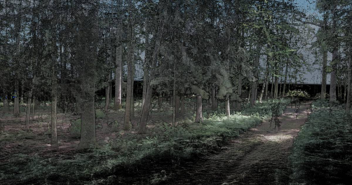
Important: LiDAR in vegetation is not only about collecting points. It is about collecting the right points, at the right geometry, and processing them properly afterward.
Penetration Myths: LiDAR Is Powerful, But Not Magic
One of the biggest myths is that any LiDAR can easily “see through” forest and dense vegetation. That is not really how it works.
- LiDAR pulses do not simply ignore vegetation
- They interact with leaves, branches, grass, shrubs, trunks, and the ground
- The final result depends on whether enough usable returns reach lower levels and the ground
- The dataset still has to be cleaned, classified, and interpreted correctly
In other words, LiDAR can provide excellent vegetation and ground information, but the quality of that result depends heavily on the sensor and workflow.
LiDAR Echo Returns: Why They Matter So Much
Echo returns are one of the most important concepts in vegetation LiDAR. A single pulse can hit several surfaces on its way down through the canopy.
- upper canopy may generate an early return
- branches or understory may create intermediate returns
- the ground may create a later return
The more returns a LiDAR system can record effectively, the better the chance of describing the full vertical structure of the vegetation.
Why Multiple Returns Matter
- better penetration through dense grass and canopy
- stronger ground identification under vegetation
- improved understanding of vegetation layers
- better tree and understory analysis
This is especially important in forestry where clients may want much more than a basic topographic surface. They may also need canopy structure, tree metrics, and vegetation characterization.
Scanning Angle Is More Important Than Many People Realize
Scan angle has a major effect on how well vegetation and trees are represented. It affects both ground penetration and the quality of tree geometry in the final point cloud.
- very oblique angles can increase shadowing and distortion
- poor scan geometry can weaken trunk definition
- scan angle influences how much of the canopy and lower structure is visible
- better angle management can improve ground extraction and structural detail
In forestry, this matters because the goal is often not just to create a surface, but to understand vertical structure. The better the scan design, the more useful the resulting dataset becomes for analysis.
Practical takeaway: good LiDAR in vegetation is not just about flying the site. It is about flying it with the right geometry.
Point Density Still Matters
Point density is another key factor. More density usually means more chances to represent trunks, branches, understory, and ground points accurately.
- higher density improves tree structure representation
- it increases the probability of useful ground points under vegetation
- it improves confidence in derived measurements
This is particularly important when clients want to extract meaningful forestry information instead of just a visual point cloud.
What Information Can Be Extracted from Forestry LiDAR?
When the capture and processing are done properly, forestry LiDAR can provide much more than a terrain model. Depending on the workflow and data quality, useful outputs can include:
- tree heights
- drip diameters and canopy spread
- tree trunk positions
- tree trunk diameters, especially when lower trunk detail is captured well
- vegetation height structure
- ground surface beneath vegetation
- tree and stand volume estimates
- forest structure around roads, utilities, and infrastructure
The key is that not all datasets support all metrics equally well. Trunk diameters, for example, require stronger lower-level capture than broad canopy mapping alone.
| Forestry Output | What Helps Most | Why It Matters |
|---|---|---|
| Tree height | ✓ Strong canopy capture | Supports inventory and growth assessment |
| Drip diameter / canopy spread | ✓ Good edge definition | Useful for canopy structure analysis |
| Trunk diameter | ✓ Good lower-trunk capture | Important for wood quality and inventory analysis |
| Ground beneath vegetation | ✓ Returns + density + good classification | Supports terrain and operational planning |
| Volume and biomass-related analysis | ✓ Full structural dataset | Supports forestry planning and valuation |
Ground Extraction Is One of the Hardest Parts
Ground extraction in dense vegetation is one of the most misunderstood parts of the LiDAR workflow. Clients often focus on acquisition, but the real challenge often comes afterward: deciding which points are actually ground and which are vegetation or noise.
- dense grass can be difficult to separate from true ground
- shrubs and brush can hide ground continuity
- uneven terrain increases classification difficulty
- bad settings can remove valid ground or keep too much vegetation
This is where experience in processing matters just as much as the sensor. Ground classification is not a one-button task when the environment is complex.
Why Combined Workflows Can Be So Powerful
One of the strongest approaches in forestry and dense vegetation work is not relying on only one platform. Different platforms provide different strengths.
Handheld SLAM
- strong for local under-canopy and lower-level detail
- useful for trunk zones and ground-level structure
- helps in spaces where aerial perspectives miss detail
UAV LiDAR
- excellent for site-scale vegetation and terrain capture
- good balance of density, flexibility, and deployment speed
- useful for stand analysis, corridors, and inventory support
Manned Aircraft LiDAR
- strong for large-scale forestry projects
- efficient for broad regional capture
- useful where coverage and production efficiency matter most
By combining handheld SLAM, UAV LiDAR, and manned aircraft LiDAR, Convex Geomatics can create very high-quality vegetation, tree, and structure point clouds across different scales and environments.
Combined approach: aerial systems give broad coverage, while handheld systems can strengthen lower-level and under-canopy detail where needed.
How This Helps the Forestry Industry
Strong forestry LiDAR datasets can help the forestry sector in several important ways:
- assessment of wood quality and timber-related structure
- better tree height and canopy characterization
- support for tree and stand volume estimation
- improved understanding of terrain and access conditions
- better vegetation mapping around roads, corridors, and assets
The value is not only in making a 3D point cloud. The value is in extracting useful forestry information from it.
How LiDAR Supports Forestry Fire Prevention and Planning
Forestry fire work is another important area where strong LiDAR can help. While no single dataset solves wildfire risk by itself, LiDAR can support better understanding of vegetation structure and fuel-related conditions.
- better understanding of canopy height and density
- identification of vegetation close to infrastructure and corridors
- support for fuel continuity analysis
- improved terrain understanding for planning access and mitigation work
- better visualization of vegetation structure in risk-prone zones
In practical terms, this can support forestry fire prevention, planning, mitigation strategies, and vegetation management around roads, utility corridors, and remote infrastructure.
Why Convex Geomatics
Convex Geomatics approaches vegetation LiDAR as a technical workflow, not just a data collection exercise. Dense grass, dense brush, and forestry canopy all behave differently, and getting the best result requires the right combination of system capability, flight design, scan geometry, and processing experience.
- we understand how returns, density, and scan angle affect forestry output
- we use top-quality LiDAR systems and combine multiple capture platforms when needed
- we focus on usable outputs, not just raw point counts
- we continue refining workflows because forestry conditions are never all the same
Our ability to combine handheld SLAM, UAV LiDAR, and manned aircraft LiDAR helps us produce strong tree, vegetation, and structure datasets from local scale to regional scale.
Need Forestry LiDAR That Actually Delivers Useful Results?
Talk to Convex Geomatics about vegetation mapping, tree analysis, corridor work, and forestry LiDAR workflows designed for real conditions in Alberta, British Columbia, and beyond.
Related Reading from Our Blog
- LiDAR vs. Photogrammetry in Alberta's Mixed Terrain: When Each Method Wins — LiDAR vs photogrammetry in Alberta
- Not All LiDAR Services Are Equal — not all LiDAR services are equal
- High-Resolution 3D Mesh Models for Inspection, Engineering, Environmental, and Other Industries — 3D mesh models for remote sites