
Overview
Convex Geomatics Ltd. provides survey-grade airborne LiDAR surveys that plug straight into design and construction. From our base in Calgary, Alberta, we map corridors, urban sites, and rugged terrain across Alberta, BC, and Saskatchewan using UAV (drone) and manned aircraft.
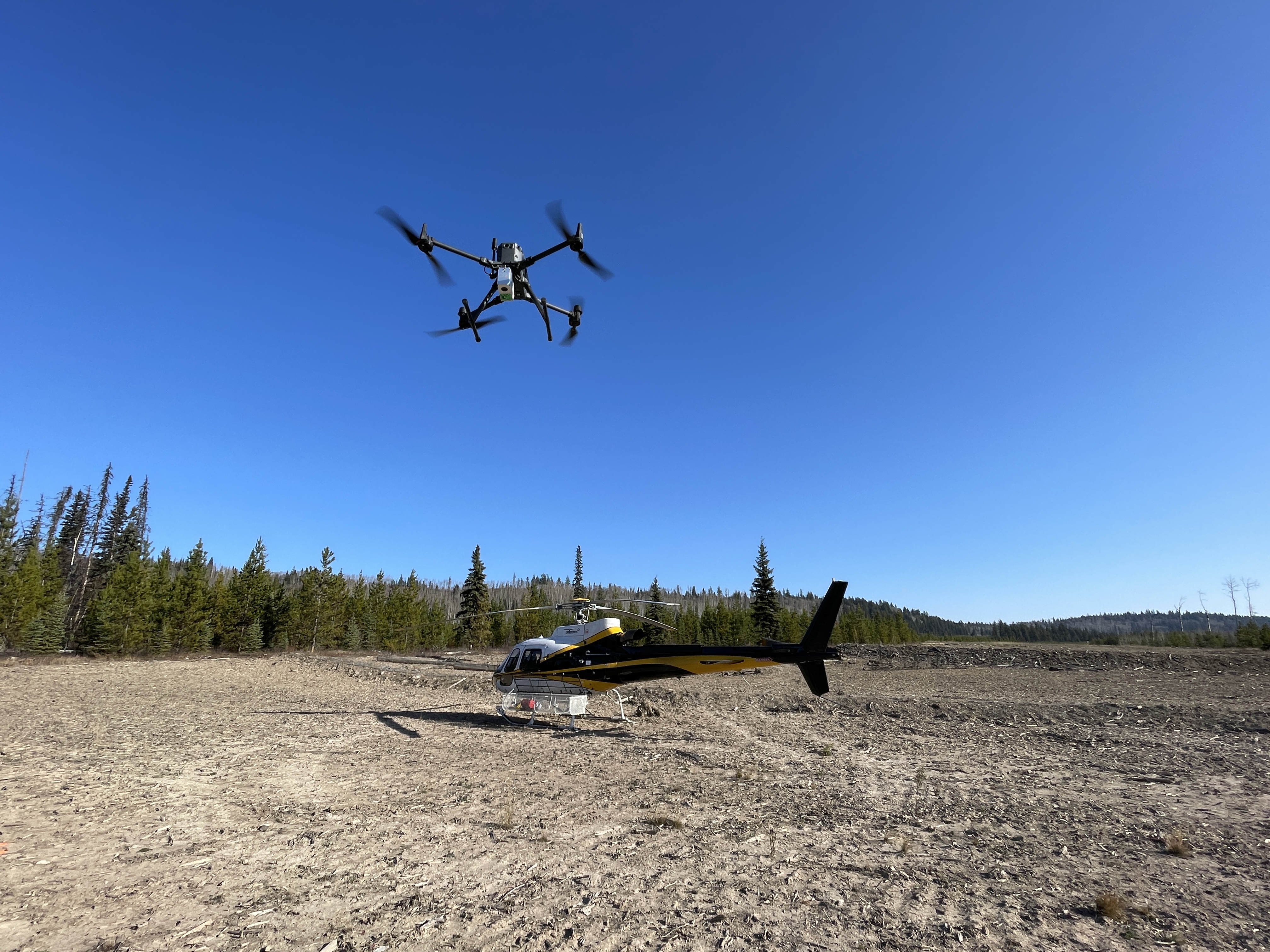
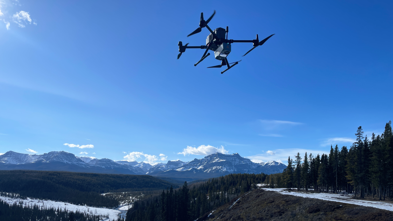
Choose the right platform. Helicopters excel where access is hard and detail matters — low, controlled flights follow powerlines, pipelines, steep slopes, and tight rights-of-way with uniform point density. Fixed-wing airplanes are ideal for long corridors and regional coverage, keeping schedules tight and unit costs predictable. We can also deploy UAV LiDAR for smaller sites and high-detail areas, or combine platforms for the best outcome. For surveys at street-level on roads or interiors, see our mobile LiDAR mapping service. For deeper context on choosing between LiDAR and photogrammetry, see our LiDAR vs Photogrammetry in Alberta comparison.
Defensible accuracy. Each project follows a disciplined workflow — GNSS/IMU PPK/PPP, boresight calibration, strip adjustment, and ground control with independent checks — delivering consistent centimetre-level performance for highways, transmission corridors, mine sites, and municipal projects. What separates a good LiDAR provider from a bad one? See our breakdown: Not All LiDAR Services Are Equal.
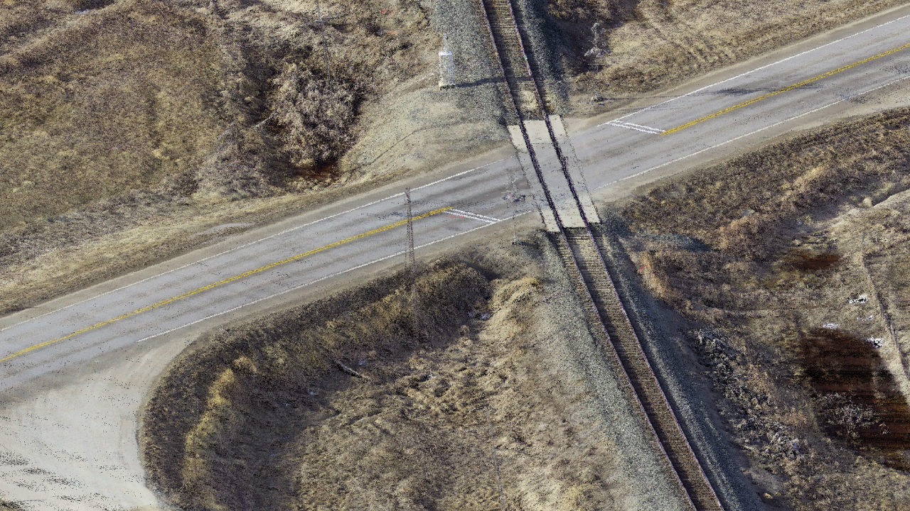
Design-ready deliverables. Receive clean, documented outputs to your standards: classified point clouds, hydro-aware terrain models and contours, breaklines, and optional orthophotos. Deliverables are available in DWG/DXF, SHP/GDB, GeoTIFF, and LAS/LAZ with clear datum/projection notes for Civil 3D, MicroStation, and ArcGIS.
Safety and compliance. Our certified UAV pilots and planners handle NAV CANADA coordination, permits, and NOTAMs where required. Expect clear schedules, proactive updates, and transparent QA/QC from mobilization to final delivery.
Tell us what you need — target accuracy, level of detail, corridor length, airspace/site constraints, and timeline. We'll design the most efficient LiDAR mapping plan for Calgary and Alberta and deliver clear, design-ready results.
LiDAR vs Other Survey Methods
Choosing the right capture method for an Alberta project depends on terrain, accuracy needs, and timeline. Here is how airborne LiDAR compares to the alternatives we offer.
| Capability | Airborne LiDAR | Photogrammetry | Mobile LiDAR | Total Station / GNSS |
|---|---|---|---|---|
| Bare-earth under vegetation | Excellent | Limited | N/A | Manual only |
| Coverage rate (km/day) | Very high | High | High (corridors) | Low |
| Vertical accuracy | ±1–6 cm | ±3–10 cm | ±2–3 cm | ±5–15 mm |
| Texture / orthophoto | Optional | Native | Optional | No |
| Cloudy / low-light conditions | Works | Limited | Works | Works |
| Best fit for | Corridors, dense canopy, terrain | Open sites, visual context | Roads, urban, interiors | Spot accuracy, layout |
For a deeper dive, read our blog on LiDAR vs Photogrammetry in Alberta and LiDAR for Forestry & Dense Vegetation.
See real LiDAR deliverables
Open our Sample Data Portal — preview orthophotos, point clouds & 3D tiles in your browser.
Why Choose Convex Geomatics for LiDAR Surveys in Alberta
- Calgary-based team with extensive local knowledge of Alberta terrain and regulations
- Flexible platforms: drone LiDAR for detail and manned aircraft for large corridors
- Seamless integration with topographic, bathymetric, and data processing services
- Engineering-grade deliverables tailored for consultants, municipalities, and energy clients
- Proven workflows with full QA/QC, PPK/PPP positioning, and clear datum documentation
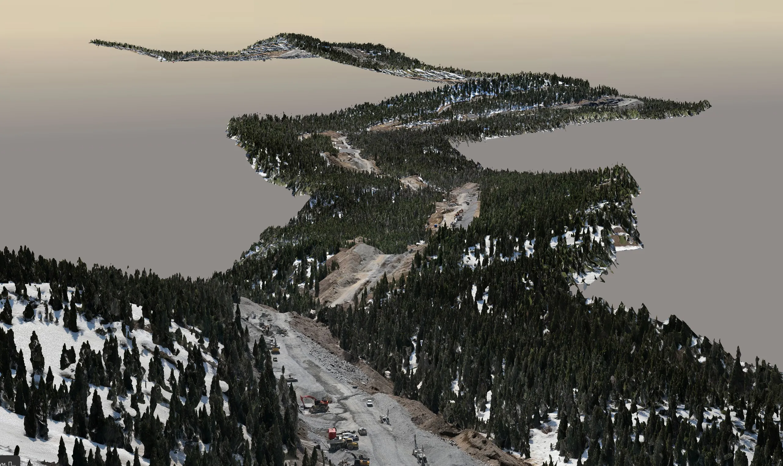
Pipeline Corridor Mapping — 200 km
High-resolution UAV and manned LiDAR scanning of a 200 km pipeline corridor in Alberta — classified point clouds, bare-earth DTM, and as-built deliverables for engineering verification.
View all projectsLiDAR Surveys for Alberta's Key Industries
Oil & Gas / Pipelines
- 200+ km corridor mapping with classified vegetation & ground points
- Right-of-way clearance analysis and as-built verification
- Pipeline integrity and encroachment detection
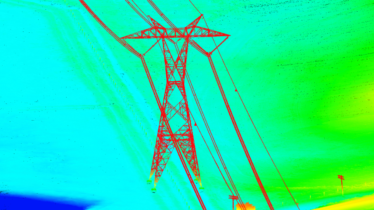
Powerlines & Transmission
- Helicopter & UAV LiDAR for dense point clouds under live lines
- Span & sag profiling, danger tree identification
- Vegetation management and compliance reporting
Forestry & Vegetation
- LiDAR through dense Alberta canopy
- Bare-earth DTM beneath boreal forest
- Wildfire planning and post-fire assessment
Mining & Aggregates
- Stockpile & pit volumetrics with centimetre accuracy
- Highwall & slope stability monitoring
- Reclamation and environmental reporting
Municipal & Infrastructure
- Floodplain & riverbank mapping
- Road & highway corridor surveys
- Urban planning and asset management
Deliverables
 Core Outputs
- Classified point cloud (LAS/LAZ)
- Digital Terrain/Surface Models (DTM/DSM)
- Contours
- Orthophotos (optional)
 Engineering Products
- Breaklines & hydro-flattened surfaces
- Ground clearing & change detection
- Cross-sections & profiles
- Vectorized transmission lines — spans & profiles
Workflow
- Project planning & airspace coordination
- GNSS/PPK control & checkpoints
- Acquisition & QA in field
- Trajectory, boresight & strip adjustment
- Classification & QA/QC
- Deliverables & review
Technology
 Sensors
- UAV LiDAR
- Airborne LiDAR
- Full frame camera
Positioning
- GNSS/IMU, PPK/PPP
- Local control & check shots