On a typical Alberta river bathymetric survey, traditional manned methods expose a 2-person crew to 6–8 days of in-water risk. A modern USV system delivers the same data in 1–2 days entirely from shore — with depth accuracy of ±0.01 m and zero crew water exposure. This article breaks down why USVs have become the standard tool for survey-grade bathymetry across Alberta, British Columbia, and Saskatchewan.
Bathymetric surveying maps the underwater terrain of lakes, rivers, reservoirs, canals, and harbours to create precise depth models. These surveys support critical work across Western Canada — from flood-risk assessment and dredging in Alberta's river systems, to infrastructure monitoring around BC Hydro projects, to environmental habitat mapping on Saskatchewan reservoirs.
Engineers and environmental consultants need reliable bathymetric data — fast. Traditional methods have meaningful limitations. Unmanned Surface Vehicles (USVs) paired with single-beam echo sounders are now the dominant tool for inland engineering bathymetry: unmatched safety, survey-grade accuracy, and CAD-ready deliverables in days instead of weeks.
Traditional Bathymetric Surveying Methods: Pros and Cons
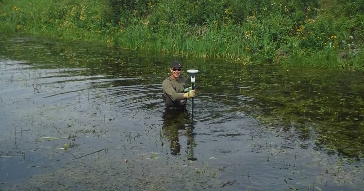
Historically, surveyors relied on manual methods — sounding poles, lead lines, and wading with GPS rods — and on manned survey vessels equipped with single-beam or multibeam echo sounders. These workflows have served the industry for decades, but they carry meaningful limitations for modern Western Canadian projects.
Pros of Traditional Methods
- Proven technology with long, established track records
- Capability for deeper-water multibeam coverage in some scenarios
- Widely understood workflows among legacy engineering teams
Cons
- Significant safety risks — crews exposed to fast currents, slippery banks, wildlife, pollution, and remote sites common in Alberta's foothills rivers, BC's coastal inlets, and Saskatchewan's expansive lakes
- Time-consuming deployment and operation — typical 6–8 field days for what a USV completes in 1–2
- Higher costs for crew, vessels, fuel, and logistics
- Limited access to shallow, narrow, or sensitive areas (bridge undersides, intakes, protected habitats)
- Slower turnaround, delaying engineering decisions by 1–3 weeks
These drawbacks make traditional methods inefficient for modern Western Canadian projects — particularly fast-turnaround engineering deliverables and sensitive environmental sites where crew risk is unacceptable.
Key Sensors Used in Bathymetric Surveying
Modern bathymetry relies primarily on acoustic sensors that transmit sound pulses toward the bottom and record return travel time to calculate depth. Choosing the right sensor for the project scope is essential to getting reliable results.
Single-Beam Echo Sounders (SBES)
- Measure depth directly beneath the sensor
- Ideal for high-accuracy targeted surveys in rivers, reservoirs, and storm ponds
- Cost-effective and highly reliable for inland engineering work
- The standard pairing for inland USV bathymetry
Multibeam Echo Sounders (MBES)
- Provide wide swath coverage of the seabed or lake bed
- Best suited for large-scale or offshore surveys
- Higher cost and often unnecessary for inland engineering work in Alberta, BC, or Saskatchewan
Single Frequency vs. Dual Frequency Echo Sounders
Echo sounders can operate at different frequencies, which directly affects how the acoustic signal interacts with the bottom — an important consideration when soft sediment is present.
Single-Frequency Echo Sounders
- Use one acoustic frequency
- Provide clean, reliable bottom detection
- Ideal for general bathymetric mapping where only the top surface is required
Dual-Frequency Echo Sounders
- Use two frequencies (typically high + low)
- High frequency = accurate top-of-bottom detection
- Low frequency = penetrates soft sediments (sludge, silt)
| Feature | Single Frequency | Dual Frequency |
|---|---|---|
| Hard bottom detection | ✓ Excellent | ✓ Excellent |
| Soft sediment penetration | ✗ Not capable | ✓ Low frequency |
| Sediment thickness analysis | ✗ Not capable | ✓ Yes |
| Dredging volume calculations | General use | ✓ Preferred |
| Environmental assessments | Basic | ✓ Comprehensive |
| Relative cost | Lower | Moderate |
Supporting Sensors: The Full Integration Stack
Accurate bathymetry depends on much more than the echo sounder alone. Proper integration of positioning and correction sensors is what separates survey-grade deliverables from basic depth profiles.
- RTK / PPK GNSS — centimetre-level horizontal positioning for every sounding
- IMU (Inertial Measurement Unit) — compensates for vessel motion: heave, pitch, roll, and yaw
- Sound Velocity Profiler (SVP) — corrects for acoustic refraction caused by temperature and salinity gradients
⚠️ Important: SVP measurements are required for water deeper than approximately 5 metres to maintain survey-grade accuracy. Without proper sound velocity correction, depth errors of 5–20 cm are common — especially in stratified water conditions typical of Alberta reservoirs and deep BC lakes.
Integrated Topo-Bathymetric Mapping
When bathymetry is combined with UAV LiDAR, topographic surveys, or mobile mapping, the result is a continuous land-to-water model that eliminates the data gap at the waterline — enabling a new class of analyses. For context on choosing the above-water capture method, see our LiDAR vs Photogrammetry in Alberta comparison.
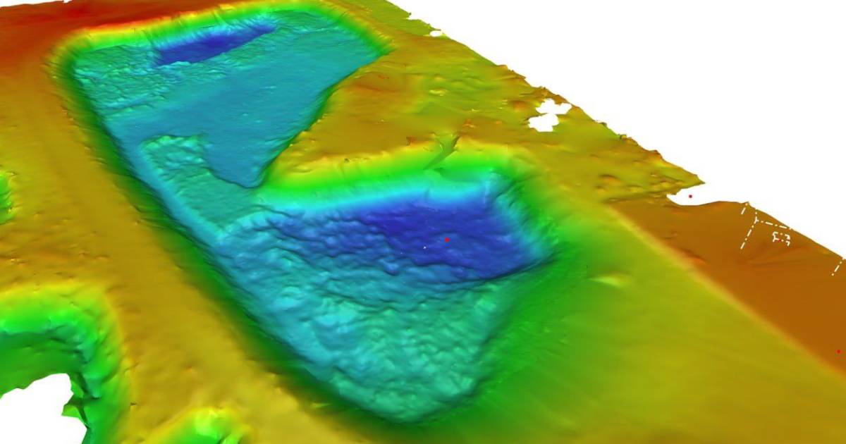
Integrated topo-bathymetric mapping enables:
- Flood modeling and inundation analysis
- Hydraulic analysis for bridge crossings and culverts
- Infrastructure design across the shoreline transition zone
- Pre/post construction comparison through the waterline
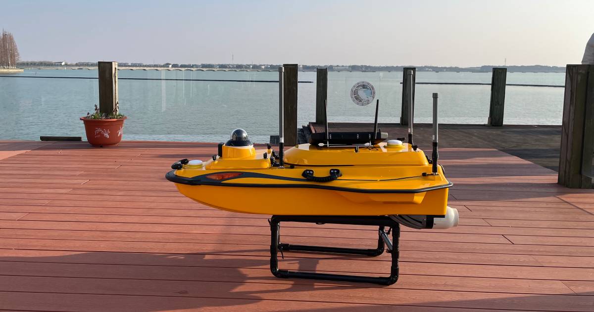
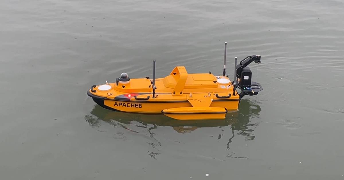
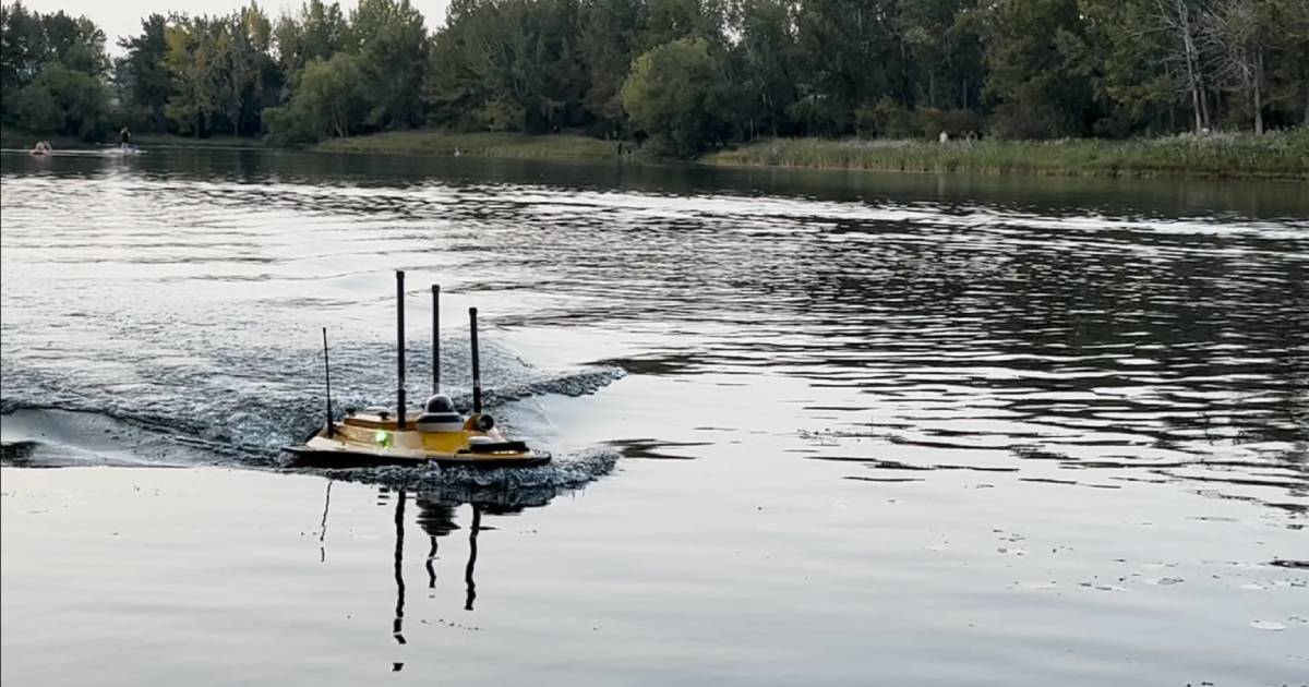
The Clear Winner: USV with Single-Beam Echo Sounders
Unmanned Surface Vehicles (USVs) equipped with survey-grade echo sounders eliminate human risk while delivering superior data quality. Here is why USVs consistently outperform traditional methods for inland survey work across Western Canada.
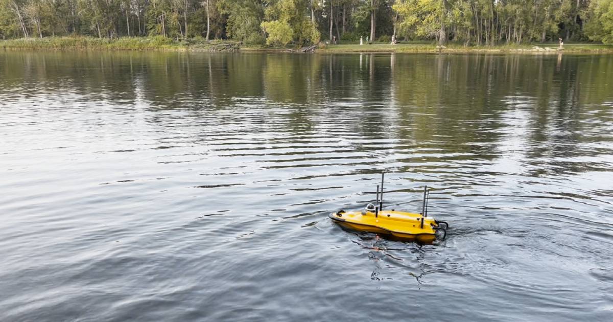
1. Exceptional Safety
USVs keep crews completely out of the water — operated remotely from shore. This is especially valuable across Western Canada's challenging survey environments:
- Alberta rivers with strong seasonal currents and debris
- BC high-flow channels and glacier-fed waterways
- Saskatchewan reservoirs with unstable weather and ice conditions
- Safe operation near infrastructure: bridges, intakes, outfalls
- Minimal wake disturbance — protects sensitive habitats and shorelines
2. Survey-Grade Accuracy
With proper setup, calibration, and correction workflows, USV systems achieve results suitable for the most demanding engineering and regulatory standards.
Advanced corrections applied to every dataset include motion compensation via IMU, sound velocity profiling with SVP casts, and full water level and tidal corrections. Published studies show RMSE values as low as ~0.04 m — suitable for engineering design, scour analysis, and environmental compliance reporting.
3. Rapid Deployment and Fast Results
USVs dramatically reduce project timelines. They launch from tight or difficult access points, operate autonomously or under remote control, and collect high-density data in a fraction of traditional survey time. Projects that previously required weeks of mobilization and crew logistics now complete in days.
Cost & Schedule Comparison
The real-world economics on a typical Western Canadian inland engineering survey:
| Approach | Crew water exposure | Field schedule | Decision turnaround | Relative cost basis |
|---|---|---|---|---|
| Manned vessel / wading GPS (traditional) | 6–8 field days | 2–3 weeks | Slower | Higher (crew, vessel, fuel, lodging) |
| USV from shore | 0 days | 3–5 days | Same-week deliverable | Typically 30–50% lower |
Deliverables: Engineering-Ready Outputs
Clients receive fully processed, QA-checked datasets formatted for immediate use in engineering and GIS workflows:
Every deliverable includes a QC report listing capture parameters, ground control RMSE, SVP cast records, and any zones where data quality is reduced (vegetation, obstructed access, surface chop) — so reviewers know what to trust and what to verify.
Real-World Applications Across Western Canada
Convex Geomatics supports a diverse range of bathymetric and hydrographic projects across Alberta, British Columbia, and Saskatchewan:
- Environmental monitoring — aquatic habitat mapping and contaminant distribution studies
- Infrastructure and flood modeling — integrating bathymetry with LiDAR for complete hydraulic models (see our 3D mesh model approach to integrated deliverables)
- Dredging project support — pre/post dredge volumes, sediment characterization
Across the 2024 field season, Convex Geomatics delivered USV bathymetric surveys across multiple municipal storm-pond networks and Bow River reaches in the Calgary area. On a representative 12-pond municipal program, our USV captured complete bathymetry in 3–4 field days from shore — work that previously required 2–3 weeks of in-water surveying with crewed vessels, with measurable improvement in both crew safety exposure and turnaround to engineering deliverables.
Frequently Asked Questions
What depth accuracy can a USV echo sounder achieve?
Survey-grade USV systems achieve ±0.01 m depth accuracy under typical conditions, with horizontal accuracy of ±2–5 cm via RTK GNSS. Published RMSE values reach ~0.04 m for engineering-grade deliverables, suitable for engineering design, scour analysis, and regulatory reporting.
When should I use dual-frequency instead of single-frequency echo sounders?
Dual-frequency is required when soft sediment such as silt or sludge is present and you need to measure both the top of sediment and the hard bottom — common in dredging, reservoir capacity studies, and storm pond siltation work. For most Alberta river and reservoir engineering surveys, single-frequency is sufficient and more cost-effective.
Why is a Sound Velocity Profiler (SVP) needed for bathymetric surveys?
SVP measurements correct for acoustic refraction caused by water temperature and salinity gradients. They are required for water deeper than approximately 5 metres to maintain survey-grade accuracy, especially in stratified Alberta reservoirs and BC lakes. Skipping SVP in deeper or stratified water typically introduces 5–20 cm of depth error.
Can USV bathymetry be combined with UAV LiDAR?
Yes. Convex Geomatics integrates USV bathymetry with UAV LiDAR to produce continuous topo-bathymetric models that eliminate the data gap at the waterline — enabling flood modeling, hydraulic analysis, and shoreline infrastructure design.
Why Convex Geomatics
Convex Geomatics is a Calgary-based, family-owned geomatics firm with 45+ years of combined experience, specializing in USV hydrographic mapping using survey-grade echo sounders. We serve clients across Alberta, British Columbia, and Saskatchewan — from prairie reservoirs and foothills rivers to coastal and inland water bodies throughout Western Canada.
Our Workflow
We deliver consistent, high-quality results through detailed planning and calibration, RTK-controlled data acquisition, full corrections (water levels, SVP, motion compensation), and professional data cleaning and QA/QC at every stage.
Integrated Survey Solutions: We combine bathymetry with UAV LiDAR, mobile mapping, and terrestrial scanning to deliver complete land-to-water models for engineering design, dredging, asset management, environmental studies, and construction projects.
Ready for a Bathymetric Quote?
Tell us your water body, target accuracy, and the deliverable formats your team needs. We'll come back with a quote and a sample of similar work — usually within one business day.
Related Reading from Our Blog
- High-Resolution 3D Mesh Models for Inspection, Engineering, Environmental, and Other Industries — high-resolution 3D mesh models
- LiDAR vs. Photogrammetry in Alberta's Mixed Terrain: When Each Method Wins — choosing the above-water capture method
- Stockpile Volumetrics: Comparing UAV LiDAR, Photogrammetry & Traditional GPS — stockpile volumetric methods