Address: 103 Riverglen Crescent SE, Calgary, Alberta, T2C 3J3

From Pixels to Precision: The Art and Science of Photogrammetric Mapping

In an era where precise spatial data is crucial for various industries, photogrammetric mapping has emerged as a transformative technology. This innovative method involves capturing images and converting them into detailed maps and 3D models, providing valuable insights for a range of applications. Convex Geomatics, a leader in high-technology surveys, specializes in photogrammetric mapping, using cutting-edge software and techniques to deliver accurate and comprehensive data. In this blog, we delve into the process of photogrammetric mapping, explore its versatility across different sectors, and highlight its benefits for land surveyors, engineers, and planners.

The Process of Photogrammetric Mapping

Photogrammetric mapping begins with the capture of high-resolution aerial photographs. These images are typically taken from aircraft or drones equipped with specialized cameras. The key to photogrammetry lies in the concept of stereoscopy, which involves capturing overlapping images from different angles. This overlap allows for the extraction of depth information, essential for creating 3D models and accurate maps.

Once the images are captured, they undergo a process called aerotriangulation. This process involves identifying common points in overlapping images and using them to determine the exact positions and orientations of the cameras at the time the photographs were taken. This information is crucial for accurately reconstructing the 3D geometry of the captured scene.

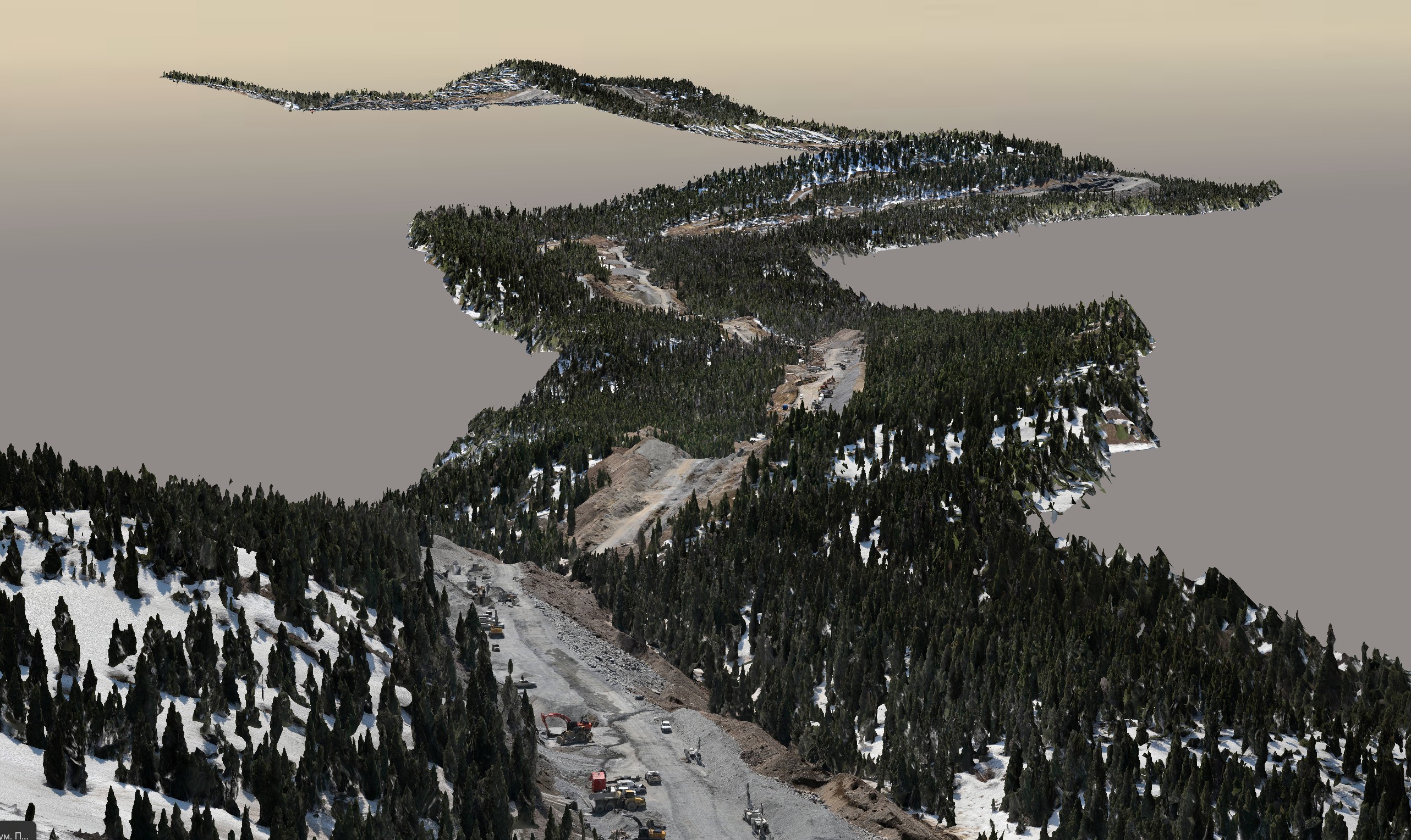
Next, the images are processed using advanced software to generate point clouds, which are collections of data points in a three-dimensional coordinate system. These point clouds represent the surface features captured in the images, such as terrain, buildings, and vegetation. From these point clouds, detailed topographic maps, orthophotos, and 3D models are created.

Orthophotos are georeferenced aerial photographs that have been corrected for lens distortion, camera tilt, and terrain relief. Unlike regular aerial photos, orthophotos provide a uniform scale, making them highly accurate for measuring distances, areas, and other spatial data.

Cutting-Edge Techniques and Software

Convex Geomatics utilizes state-of-the-art software and techniques to ensure the highest accuracy and quality in photogrammetric mapping. By employing sophisticated algorithms and tools, they can process large datasets efficiently and produce detailed outputs. The use of high-resolution cameras and sensors further enhances the precision of the captured data, allowing for the creation of maps and models with fine detail.

One of the key advantages of photogrammetric mapping is its ability to cover large areas quickly and cost-effectively. Whether it’s a vast agricultural field, a sprawling urban area, or a remote forest, photogrammetry can capture the necessary data with minimal ground access. This efficiency is particularly valuable in time-sensitive applications, such as disaster response and environmental monitoring.

Versatility in Applications

The versatility of photogrammetric mapping makes it an invaluable tool across various sectors. In agriculture, for instance, it enables farmers and agronomists to monitor crop health, assess soil conditions, and plan irrigation systems. By analyzing multispectral images, they can detect issues such as pest infestations, nutrient deficiencies, and water stress, allowing for timely interventions that can improve yield and reduce costs.

In environmental monitoring, photogrammetric mapping plays a crucial role in tracking changes in land use, vegetation cover, and natural habitats. This information is essential for conservation efforts, urban planning, and climate change studies. By providing a detailed and accurate record of the landscape, photogrammetry helps researchers and policymakers make informed decisions about land management and conservation strategies.

Disaster management is another area where photogrammetric mapping proves invaluable. In the aftermath of natural disasters like floods, earthquakes, or wildfires, rapid and accurate assessment of the affected areas is crucial for coordinating rescue and relief efforts. Photogrammetric maps and models can quickly provide detailed information about damage to infrastructure, changes in terrain, and access routes, aiding in efficient disaster response and recovery.

Benefits for Land Surveyors, Engineers, and Planners

For land surveyors, engineers, and planners, photogrammetric mapping offers a range of benefits that enhance their work and decision-making processes. The high accuracy and resolution of photogrammetric data make it ideal for creating topographic maps, land use maps, and 3D models that are essential for designing infrastructure projects, urban planning, and environmental assessments.

One of the key advantages of photogrammetry is its ability to provide a comprehensive view of a project site without the need for extensive ground surveys. This capability is particularly useful in challenging or inaccessible terrain, where traditional survey methods may be impractical or time-consuming. By capturing data from the air, photogrammetry can cover large areas quickly and with minimal disruption to the environment.

The integration of photogrammetric data with Geographic Information Systems (GIS) further enhances its utility. GIS allows for the analysis and visualization of spatial data, enabling planners and engineers to overlay different types of information, such as population density, land use, and infrastructure networks. This holistic view helps in making informed decisions about site selection, zoning, and resource allocation.

Cost-Effective and Timely Solutions

One of the most significant advantages of photogrammetric mapping is its cost-effectiveness. Compared to traditional surveying methods, photogrammetry requires fewer resources, both in terms of manpower and equipment. The ability to capture data from the air also reduces the time needed for fieldwork, translating into faster project turnaround times.

Furthermore, the use of drones in photogrammetry has made the technology even more accessible and affordable. Drones can be deployed quickly and easily, capturing high-resolution images with great precision. This flexibility allows for frequent updates to maps and models, ensuring that stakeholders have access to the most current data.

Conclusion

Photogrammetric mapping represents the intersection of art and science, transforming pixels into precise and detailed maps and models. With its wide range of applications and numerous benefits, photogrammetry is a powerful tool for land surveyors, engineers, planners, and other professionals. Convex Geomatics is at the forefront of this technology, leveraging cutting-edge software and techniques to deliver accurate and cost-effective solutions. As the demand for precise spatial data continues to grow, photogrammetric mapping will play an increasingly important role in shaping the future of various industries.

Leave a Reply

Your email address will not be published. Required fields are marked *